When faced with the question of ‘what resolution is best for my impact modelling’, the obvious answer seems to be ‘the smallest grid possible’. But you might be surprised...
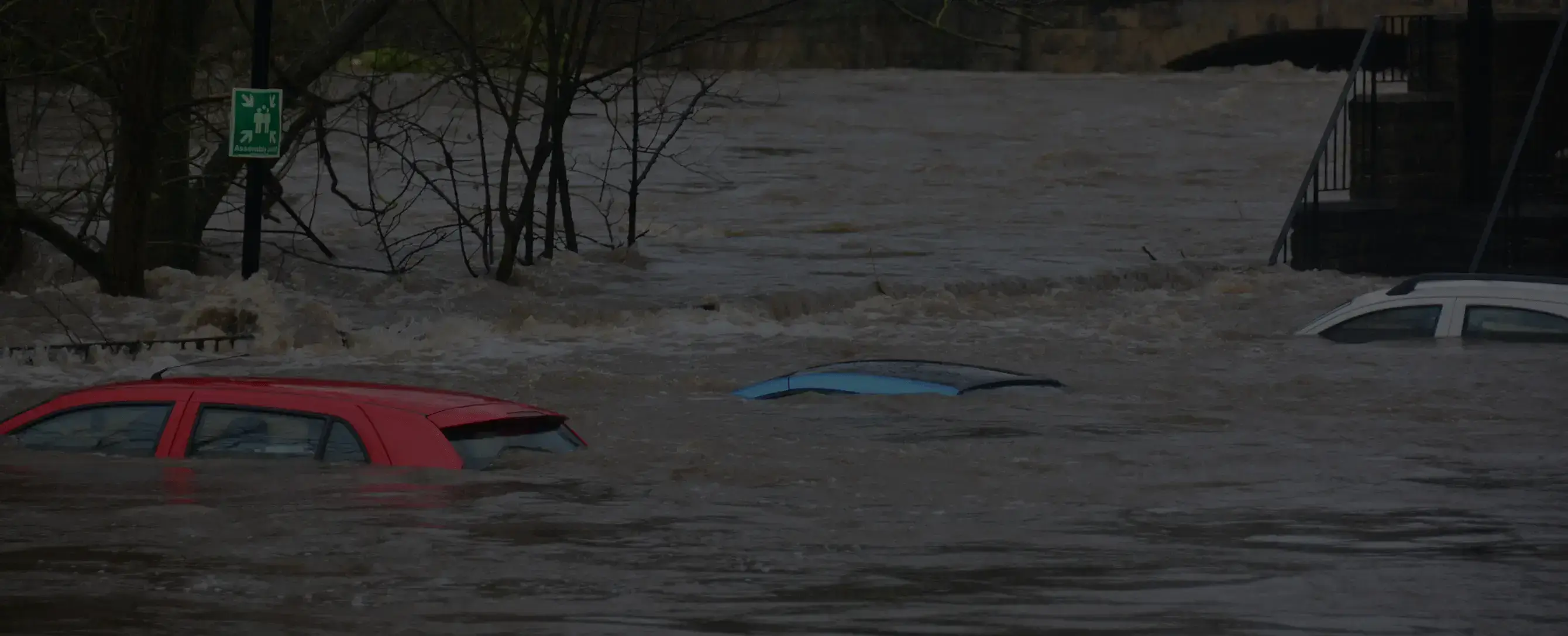
Flooding has been the costliest impact of climate change in terms of loss and damage in places like the UK, China, Pakistan and even East Australia in recent years. A trustworthy and detailed flood risk assessment will be high on the list of priorities for anyone looking to assess their climate risk.
There are many things to consider when assessing the suitability of a flood model for climate risk. The top three are:
- For climate change, the future will be different to the past - does my model or provider appreciate and capture that?
- How strong is the science – is the model based on physics or does it use statistical trends?
- How well are local features on the ground quantified? What’s the resolution of the model?
It’s intuitive to think that finer resolution is always better, but there is strong scientific evidence showing flood models of resolutions finer than 10-30m offer no improvement in accuracy at predicting flood extent. In fact, claims of very high precision can often be misleading, and may disguise high levels of uncertainty, or limitations in the accuracy of the data that underpins the model itself1.
1. Garbage in = garbage out
Flood models are built on observational data about the landscape; then, we simulate water flowing through this digital twin to derive flood maps.
To build a flood model, the minimum that we need to know is the shape of the landscape; ideally, we would also know where rivers and other water sources are, where buildings are, where there is concreted or vegetated ground, and as much detail about water currently in or on the land. A terrain map which tells you about the height and slope of the land is called a digital elevation model or DEM. These are produced from satellite data or LiDAR data from aircraft. The typical best resolution of a global DEM is 30m – this is produced from satellite, so the resolution is limited. It is possible to generate a DEM with a resolution of 1m or even less using data gathered from aircraft, but since the range of any aircraft is limited, the DEM that is produced tends to cover relatively small areas of land. This makes it very hard to get uniform coverage over whole countries or continents, and requires data from every flight to be stitched together.

The DEM is the most important input to an accurate flood model. Its resolution dictates how well you can ‘see’ features on the ground such as buildings, roads and local depressions in the land. The DEM dictates where water will end up in your flood model.
It is not scientifically sound to create a model with a smaller resolution than the inputs on which it is built. When the DEM has a 30m resolution, then it is scientifically dubious to model a flood at 5m or 10m.
2. How do you know the model is correct and accurate?
Understanding how realistic your model is compared to the real world is as important as what the model tells you in the first place. Renowned statistician, George Box, is famously quoted to have said, “All models are wrong, but some are useful”; the important thing to know when assessing the quality of any model is how wrong and how useful. Validation can tell you both.
The most robust way to validate the performance of a flood model is to compare it with floods that happened in the past and see how accurately your model reproduces them. Validation data often comes in the form of a map of flood extent for a particular date. This data needs to be at the same or better resolution than the flood model, or you won’t be able to say if it is correct (you can’t validate on a smaller spatial scale than you observed in the past). It is very rare for observations of historical flood extent to be available at smaller than 10m resolution.
Normally when there is a flood, the weather is cloudy, so high-precision satellite images for historical flood extent are hard to come by. One way we map historical flood extent in the UK [here] is using RADAR observations from satellite. RADAR from satellites can see through clouds; the typical best resolution is 10m, but frequently we don’t achieve this quality. We are also reliant on the satellite passing overhead of a flooded location at the time of maximum flood extent.
A flood model with 5m or 10m (or even smaller) resolution is very difficult or almost impossible to validate.
3. At a certain point, having a model with very small resolution does not provide additional benefits
Imagine you have a flood model with a 1m resolution that is miraculously built on reliable input data and has meaningful and exceptional validation. You can now reliably tell which parts of which rooms in your house will be flooded. But does it actually help you to know which parts of a building are flooded to the 1m level of detail? Do you have the in-house capability to calculate loss and damage at that level of detail?
If an asset is bigger than the resolution of the model, then which of the grid squares that the asset sits in is the one that will be used to say how deep the water in the asset is and hence how much it is damaged? Many non-expert (non-scientist) data users would typically take an average over all the small grid squares that an asset sits in and hence eliminate any potential benefit given by a fine-resolution model.
If the water is in your house, then the carpet and electricity are all going to need replacing, even if the flood is only on one side of the living room. (Also, if only one side of the living room is flooded, you have a wonky floor and should probably have a look at your subsidence risk as well!)
Summing up
The resolution of a flood model and the resulting flood hazard/risk data are limited by the resolution of the input data. Fine resolutions of less than 10-30m may not improve accuracy, and validation data is often only available at 10m resolution or coarser. Models with very small resolutions can also be computationally expensive to run and may not provide additional benefits. Ultimately, the appropriate resolution for a flood model depends on the specific use case and available data.
In some use cases for flood risk data, it may be necessary to conduct a detailed high-resolution flood risk assessment of a small area. To ensure accuracy, such an assessment should include more local-level data, such as the drainage network and other physical features specific to the area. In these cases, a 1m scale model may be necessary.
However, for a portfolio of assets spread over a national or global area, such detailed modelling may not be practical or useful.
There is a lower limit for flood model resolution and usefulness; whilst 1m may be too small to be useful for asset management, 1km is too large for a useful flood risk assessment. The landscape can meaningfully change over 1km, but not over 1m scales - local features of a certain size (local lumps in terrain, major roadways, etc.) have a big effect on where flooding can occur.
To determine the appropriate resolution for your needs, consider the size of your assets, the information you need to know, and the data capabilities of your team.
